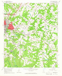
1964 Map of Athens East
USGS Topo · Published 1966About this map
The North Fork Oconee River and Middle Oconee River converge south of the growing city of Athens, defining a landscape where university research facilities meet rural family land. Educational and agricultural development is evident at the University of Georgia Poultry Research Center and the Whitehall Farm near the community of Whitehall. Transport networks are densely clustered in the northwest, where the Seaboard Air Line and Georgia Railroad intersect. Further east, the town of Winterville sits along the rail line, surrounded by traditional landmarks like New Grove Ch and several family burial grounds, including the Lester Cem and Morton Cem. This era shows the expansion of the Athens Municipal Airport and the establishment of residential areas like Green Acres, illustrating the mid-century shift from agrarian life to suburban development.
Find a feature on this map
71 named features on this map. Tap any name to fly to it.
Don’t see what you’re looking for? This feature index may not catch every label — zoom into the map to look around manually.
Map Details
Editions of this 1964 Athens East Map
Other maps of this area

1891 · Carnesville
USGS Topo · 1:125,000

1953 · Athens
USGS Topo · 1:250,000

1954 · Greenville
USGS Topo · 1:250,000

1958 · Greenville
USGS Topo · 1:250,000

1958 · Athens
USGS Topo · 1:250,000

1958 · Danielsville
USGS Topo · 1:62,500

1959 · Athens
USGS Topo · 1:250,000

1963 · Athens
USGS Topo · 1:250,000

1964 · Athens West
USGS Topo · 1:24,000

1964 · Barnett Shoals
USGS Topo · 1:24,000