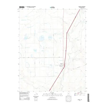
2013 Map of Maxwell
USGS Topo · Published 2013About this map
Maxwell serves as the central hub of this Colfax County landscape, where human engineering and natural waterways converge. The town is situated just west of the Canadian River and north of the Vermejo River, surrounded by a complex network of irrigation infrastructure designed to sustain the arid plains. Notable water control features include the Siphon Ditch, Highline Ditch, and Dyke Ditch, which feed into a series of numbered reservoirs such as Number Fourteen Lake, Number Twelve Lake, and Reservoir Number 13.
Find a feature on this map
45 named features on this map. Tap any name to fly to it.
Don’t see what you’re looking for? This feature index may not catch every label — zoom into the map to look around manually.
Map Details
Editions of this 2013 Maxwell Map
This is the sole edition of this map. No revisions or reprints were ever made.
Other maps of this area

1915 · Koehler
USGS Topo · 1:62,500

1917 · Koehler
USGS Topo · 1:62,500

1954 · Raton
USGS Topo · 1:250,000

1958 · Raton
USGS Topo · 1:250,000

1965 · Abbott NW
USGS Topo · 1:24,000

1965 · French
USGS Topo · 1:24,000

1965 · Springer Lake
USGS Topo · 1:24,000

1971 · Saltpeter Mountain
USGS Topo · 1:24,000
1971 · Eagle Tail Mountain
USGS Topo · 1:24,000
1971 · Loco Arroyo
USGS Topo · 1:24,000