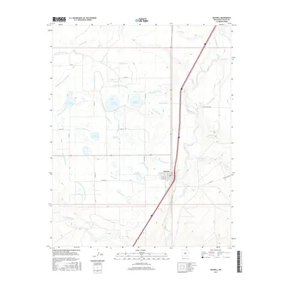
2017 Map of Maxwell
USGS Topo · Published 2017About this map
Maxwell serves as the focal point of this Colfax County landscape, defined by a sophisticated and extensive network of water management infrastructure. The region is interlaced with numerous irrigation features including the Stubblefield-Eagle Tail Lateral, Siphon Ditch, and Number 11 Lateral. These canals and ditches feed a series of numerically designated reservoirs such as Number Thirteen Lake, Number Fourteen Lake, and Number Twelve Lake. To the east, the Canadian River meanders southward, joined by tributaries like Crow Cr and Loco Arroyo. This intricate web of laterals and siphons illustrates a desert landscape transformed by hydraulic engineering to support agriculture and settlement near the Vermejo River. The road network, including Tenaja Ave and Vermejo Ave, radiates from the town center, providing a clear view of the community's mid-20th-century footprint.
Find a feature on this map
47 named features on this map. Tap any name to fly to it.
Don’t see what you’re looking for? This feature index may not catch every label — zoom into the map to look around manually.
Map Details
Editions of this 2017 Maxwell Map
This is the sole edition of this map. No revisions or reprints were ever made.
Other maps of this area

1915 · Koehler
USGS Topo · 1:62,500

1917 · Koehler
USGS Topo · 1:62,500

1954 · Raton
USGS Topo · 1:250,000

1958 · Raton
USGS Topo · 1:250,000

1965 · Abbott NW
USGS Topo · 1:24,000

1965 · French
USGS Topo · 1:24,000

1965 · Springer Lake
USGS Topo · 1:24,000

1971 · Saltpeter Mountain
USGS Topo · 1:24,000
1971 · Eagle Tail Mountain
USGS Topo · 1:24,000
1971 · Loco Arroyo
USGS Topo · 1:24,000