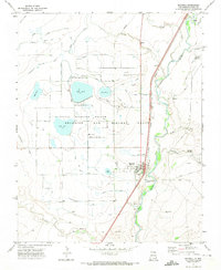
1971 Map of Maxwell
USGS Topo · Published 1974About this map
The town of Maxwell sits at the heart of a sophisticated irrigation network in the early 1970s, bounded by the historic Beaubien and Miranda Grant. This landscape is defined by its water management, featuring a dense grid of canals and ditches such as the Eagle Tail Lateral, Highline Ditch, and Red River Ditch. These waterways feed a series of numbered reservoirs, including Lake No 13 and Lake No 12, which now comprise the Maxwell National Wildlife Refuge.
Find a feature on this map
45 named features on this map. Tap any name to fly to it.
Don’t see what you’re looking for? This feature index may not catch every label — zoom into the map to look around manually.
Map Details
Editions of this 1971 Maxwell Map
This is the sole edition of this map. No revisions or reprints were ever made.
Other maps of this area

1915 · Koehler
USGS Topo · 1:62,500

1917 · Koehler
USGS Topo · 1:62,500

1954 · Raton
USGS Topo · 1:250,000

1958 · Raton
USGS Topo · 1:250,000

1965 · Abbott NW
USGS Topo · 1:24,000

1965 · French
USGS Topo · 1:24,000

1965 · Springer Lake
USGS Topo · 1:24,000

1971 · Saltpeter Mountain
USGS Topo · 1:24,000
1971 · Eagle Tail Mountain
USGS Topo · 1:24,000
1971 · Loco Arroyo
USGS Topo · 1:24,000