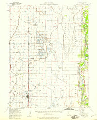
1952 Map of Maxwell
USGS Topo · Published 1958About this map
The Sacramento National Wildlife Refuge dominates the heart of this Sacramento Valley landscape, revealing an intricate system of duck ponds and water management in the early 1950s. The town of Maxwell serves as a local hub along the Southern Pacific railroad, featuring the Union High Sch and a local landing strip. To the east, the Sacramento River meanders through a series of dramatic bends and islands, including Hanson Island and Packer Island, while the Colusa Trough and various gun clubs like the Willow Creek Gun Club indicate the region's importance for waterfowl and irrigation. Smaller agricultural settlements and sidings like Logandale, Norman, and Riz Siding highlight the rail-dependent economy of the era. The presence of the Cachil Dehe Rancheria near the river provides a significant touchstone for local indigenous history.
Find a feature on this map
66 named features on this map. Tap any name to fly to it.
Don’t see what you’re looking for? This feature index may not catch every label — zoom into the map to look around manually.
Map Details
Editions of this 1952 Maxwell Map
2 editions found
Other maps of this area

1888 · Marysville
USGS Topo · 1:125,000

1891 · Chico
USGS Topo · 1:125,000

1891 · Marysville
USGS Topo · 1:125,000

1893 · Chico
USGS Topo · 1:125,000

1894 · Marysville
USGS Topo · 1:125,000

1895 · Marysville
USGS Topo · 1:125,000

1895 · Chico
USGS Topo · 1:125,000

1904 · Logan Creek
USGS Topo · 1:24,000

1904 · Sites
USGS Topo · 1:24,000

1905 · Fairview
USGS Topo · 1:24,000