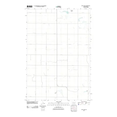
2011 Map of May Lake
USGS Topo · Published 2011About this map
May Lake and its surrounding wetlands anchor this McIntosh County landscape, reflecting the prairie pothole geography of central North Dakota. The area is defined by a rigid section-line road grid, including 81st ST Se and 38th Ave Se, which facilitates the region's agricultural layout. Local infrastructure is concentrated in the northern portion of the quadrangle near the Wishek Municipal Airport, while the southern reaches feature the Danzig Cemetery, a primary point of interest for family historians and genealogists researching the legacy of the area's rural communities. Small water management features like Girft Dam suggest the importance of local water control in an environment where intermittent ponds and depressions are common across the plains.
Find a feature on this map
18 named features on this map. Tap any name to fly to it.
Don’t see what you’re looking for? This feature index may not catch every label — zoom into the map to look around manually.
Map Details
Editions of this 2011 May Lake Map
This is the sole edition of this map. No revisions or reprints were ever made.
Other maps of this area

1953 · Jamestown
USGS Topo · 1:250,000

1956 · Jamestown
USGS Topo · 1:250,000

1982 · Wishek SW
USGS Topo · 1:24,000

1982 · Danzig
USGS Topo · 1:24,000

1982 · May Lake NW
USGS Topo · 1:24,000

1982 · May Lake SW
USGS Topo · 1:24,000

1982 · May Lake
USGS Topo · 1:24,000
1982 · May Lake SE
USGS Topo · 1:24,000

1982 · Lehr SW
USGS Topo · 1:24,000
1982 · Ashley West
USGS Topo · 1:24,000