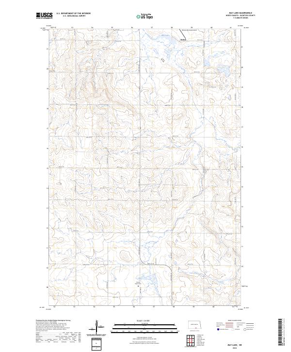
2024 Map of May Lake
USGS Topo · Published 2024About this map
Wishek occupies the northern edge of this McIntosh County landscape, situated near the Wishek Municipal Airport and the waters of May Lake. This portion of North Dakota is defined by a rhythmic grid of rural section roads, including 37th Ave SE and 81st St SE, which partition the undulating prairie. In the southern reach of the survey, the Danzig Baptist Cem serves as a significant genealogical landmark, located along 39th Ave SE. The terrain is characterized by numerous small wetlands and depressions typical of the region's glacial topography, with the land divisions of t132n r71w and surrounding townships providing the primary structural framework for the sparse farmstead distribution.
Find a feature on this map
23 named features on this map. Tap any name to fly to it.
Don’t see what you’re looking for? This feature index may not catch every label — zoom into the map to look around manually.
Map Details
Editions of this 2024 May Lake Map
This is the sole edition of this map. No revisions or reprints were ever made.
Other maps of this area

1953 · Jamestown
USGS Topo · 1:250,000

1956 · Jamestown
USGS Topo · 1:250,000

1982 · Wishek SW
USGS Topo · 1:24,000

1982 · Danzig
USGS Topo · 1:24,000

1982 · May Lake NW
USGS Topo · 1:24,000

1982 · May Lake SW
USGS Topo · 1:24,000

1982 · May Lake
USGS Topo · 1:24,000
1982 · May Lake SE
USGS Topo · 1:24,000

1982 · Lehr SW
USGS Topo · 1:24,000
1982 · Ashley West
USGS Topo · 1:24,000