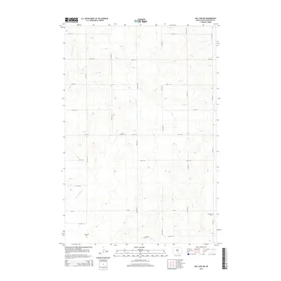
2014 Map of May Lake NW
USGS Topo · Published 2014About this map
S Branch Beaver Cr meanders through the rolling terrain of McIntosh County, providing the primary drainage for this rural agricultural landscape. The map reveals a strict section-line grid of local roads, such as 85th St SE and 33rd Ave SE, which define the pattern of land use and access for the area's farming community. For genealogists and local historians, the sheet is particularly valuable for its documentation of four distinct burial grounds. The presence of Beaver Creek Cem, Ebenezer Cem, Old Kassel Cem, and Saint Johns Cem scattered across the landscape suggests the locations of early settlement clusters and congregational centers that may no longer have standing buildings. These sites, along with the primary thoroughfare of CR-2610, anchor the history of this prairie region.
Find a feature on this map
20 named features on this map. Tap any name to fly to it.
Don’t see what you’re looking for? This feature index may not catch every label — zoom into the map to look around manually.
Map Details
Editions of this 2014 May Lake NW Map
This is the sole edition of this map. No revisions or reprints were ever made.
Other maps of this area

1953 · Jamestown
USGS Topo · 1:250,000

1956 · Jamestown
USGS Topo · 1:250,000

1979 · Schell Buttes
USGS Topo · 1:24,000
1980 · Hague SE
USGS Topo · 1:24,000

1982 · Wishek SW
USGS Topo · 1:24,000

1982 · May Lake NW
USGS Topo · 1:24,000

1982 · May Lake SW
USGS Topo · 1:24,000

1982 · May Lake
USGS Topo · 1:24,000
1982 · May Lake SE
USGS Topo · 1:24,000

1982 · Wishek
USGS Topo · 1:24,000