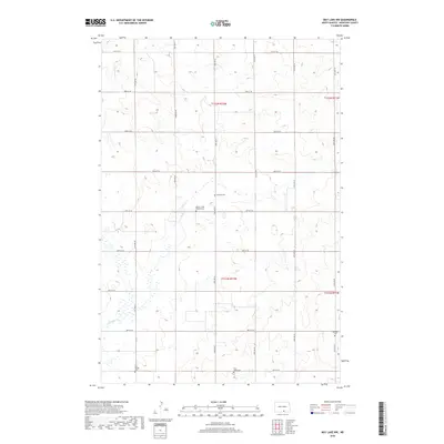
2018 Map of May Lake NW
USGS Topo · Published 2018About this map
Scattered cemeteries and the winding course of the S Br Beaver Cr define this rural landscape of McIntosh County. This 2018 survey documents a region dominated by agricultural grid lines, with section roads like 85th St SE and 33rd Ave SE providing the primary structure for the few remaining points of interest. The distribution of burial grounds across these sections provides a map of early German-Russian settlement patterns in the Dakotas. Significant genealogical sites include the Beaver Creek Baptist Cem and Neudorf Cem in the northern sections, while the southern reaches of the quadrangle contain Saint Johns Cem and the Old Kasset Cem. These small, localized cemeteries often represent the only surviving physical evidence of the pioneer communities and rural church congregations that once anchored these townships.
Find a feature on this map
20 named features on this map. Tap any name to fly to it.
Don’t see what you’re looking for? This feature index may not catch every label — zoom into the map to look around manually.
Map Details
Editions of this 2018 May Lake NW Map
This is the sole edition of this map. No revisions or reprints were ever made.
Other maps of this area

1953 · Jamestown
USGS Topo · 1:250,000

1956 · Jamestown
USGS Topo · 1:250,000

1979 · Schell Buttes
USGS Topo · 1:24,000
1980 · Hague SE
USGS Topo · 1:24,000

1982 · Wishek SW
USGS Topo · 1:24,000

1982 · May Lake NW
USGS Topo · 1:24,000

1982 · May Lake SW
USGS Topo · 1:24,000

1982 · May Lake
USGS Topo · 1:24,000
1982 · May Lake SE
USGS Topo · 1:24,000

1982 · Wishek
USGS Topo · 1:24,000