1950 Map of Mayaguez NE
USGS Topo · Published 1950About this map
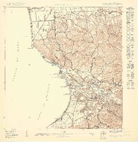
The coastal city of Mayagüez serves as a dense urban hub in this mid-century topographic survey, where the harbor front is defined by Marina Septentrional and Marina Meridional. The American Railroad corridor traces the shoreline, supporting a regional economy tied to the sea and the fertile hills of Algarrobos and Miradero. A notable cluster of institutional landmarks stands out, including the Universidad de Puerto Rico Colegio de Agricultura y Artes Mecánicas and the nearby US Dept of Agriculture Experiment Station, highlighting the area's importance for agricultural research.
Find a feature on this map
39 named features on this map. Tap any name to fly to it.
Don’t see what you’re looking for? This feature index may not catch every label — zoom into the map to look around manually.
Map Details
Editions of this 1950 Mayaguez NE Map
This is the sole edition of this map. No revisions or reprints were ever made.
Other maps of this area

1938 · Alto Sano
USGS Topo · 1:20,000

1939 · Mayaguez
USGS Topo · 1:30,000

1941 · Rincon
USGS Topo · 1:30,000

1941 · Rincon
USGS Topo · 1:30,000

1941 · Rosario
USGS Topo · 1:30,000

1942 · Central La Plata
USGS Topo · 1:30,000

1942 · Rosario
USGS Topo · 1:30,000

1946 · Ciales
USGS Topo · 1:30,000

1947 · Rincon
USGS Topo · 1:30,000

1947 · Rincon
USGS Topo · 1:30,000