
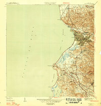
1950 Map of Mayaguez SE
USGS Topo · Published 1950About this map
Agricultural colonization and sugar production define this mid-century landscape along the western coast of Puerto Rico. The Central Rochelaise serves as a focal point for the surrounding region, connected by the tracks of the American Railroad of Porto Rico. Extensive plantation lands, identified as colonias, such as Colonia Esperanza and Colonia Cornelia, illustrate the dominant land-use patterns of the era. The terrain transitions from the marshy lowlands near Caño Corazones and Laguna Bocanasilla to the prominent heights of Cuesta de las Piedras and Cerro Cornelia.
Find a feature on this map
45 named features on this map. Tap any name to fly to it.
Don’t see what you’re looking for? This feature index may not catch every label — zoom into the map to look around manually.
Map Details
Editions of this 1950 Mayaguez SE Map
This is the sole edition of this map. No revisions or reprints were ever made.
Other maps of this area

1935 · Puerto Real
USGS Topo · 1:25,000

1937 · San German
USGS Topo · 1:25,000

1937 · Puerto Real
USGS Topo · 1:25,000

1939 · Mayaguez
USGS Topo · 1:30,000

1941 · San German
USGS Topo · 1:30,000

1941 · Puerto Real
USGS Topo · 1:30,000

1941 · Rosario
USGS Topo · 1:30,000

1942 · Rosario
USGS Topo · 1:30,000
1947 · Mayaguez
USGS Topo · 1:30,000
1949 · Puerto Real NE
USGS Topo · 1:10,000
Featured Places
- Hormigueros, Hormigueros
- Cerillos, Cabo Rojo
- Reparto Galiano, Hormigueros
- Mayagüez
- Sábalos Gardens, Mayagüez