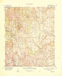
1948 Map of Mayer
USGS Topo · Published 1948About this map
Mining operations dominate the landscape of the Prescott National Forest in this post-war survey. Significant industrial activity is clustered along the western ridges, featuring the Blue Bell Mine, Binghamton Mine, and the notable Tallest Stack near the Red Tank Mine. These operations were served by the At & SF RR, which connects the settlements of Mayer and Cleator. The presence of numerous specialized claims like the Pick & Drill Mine and Hidden Treasure Peak suggests a period of intensive mineral exploration and extraction.
Find a feature on this map
107 named features on this map. Tap any name to fly to it.
Don’t see what you’re looking for? This feature index may not catch every label — zoom into the map to look around manually.
Map Details
Editions of this 1948 Mayer Map
This is the sole edition of this map. No revisions or reprints were ever made.
Other maps of this area

1887 · Verde
USGS Topo · 1:250,000

1887 · Prescott
USGS Topo · 1:250,000

1892 · Verde
USGS Topo · 1:250,000

1892 · Prescott
USGS Topo · 1:250,000

1903 · Bradshaw Mountains
USGS Topo · 1:125,000

1905 · Jerome
USGS Topo · 1:125,000

1923 · Camp Verde
USGS Topo · 1:125,000

1929 · Turret Peak
USGS Topo · 1:125,000

1932 · Camp Verde
USGS Topo · 1:125,000

1933 · Turret Peak
USGS Topo · 1:125,000