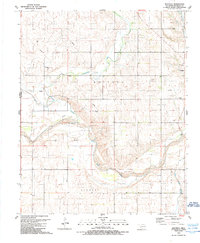
1989 Map of Mayfield
USGS Topo · Published 1989About this map
Mayfield and the surrounding plains of western Oklahoma are defined by the convergence of several vital waterways and a robust energy infrastructure. The North Fork Red River meanders across the southern landscape, joined by tributaries such as Sweetwater Creek, Buffalo Creek, and Salt Creek. This 1989 survey captures a period of industrial activity within the Buffalo Field and Gas Field, where an extensive network of pipelines connects numerous Gas Wells to a central Gas Treatment Facility. Local life is anchored by the Mayfield Cem and a Community Center, with the Tittle Bridge providing a key crossing point over the river. The terrain transitions into the Texola region near the state line, illustrating the sparsely populated but economically active character of Beckham County as it was toward the end of the 20th century.
Find a feature on this map
19 named features on this map. Tap any name to fly to it.
Don’t see what you’re looking for? This feature index may not catch every label — zoom into the map to look around manually.
Map Details
Editions of this 1989 Mayfield Map
This is the sole edition of this map. No revisions or reprints were ever made.
Other maps of this area

1954 · Amarillo
USGS Topo · 1:250,000

1955 · Clinton
USGS Topo · 1:250,000

1957 · Clinton
USGS Topo · 1:250,000

1958 · Amarillo
USGS Topo · 1:250,000

1960 · Sweetwater
USGS Topo · 1:62,500

1961 · Erick
USGS Topo · 1:62,500

1962 · Kelton SE
USGS Topo · 1:24,000

1963 · Kelton
USGS Topo · 1:24,000

1963 · Fulller
USGS Topo · 1:24,000
1983 · Shamrock
USGS Topo · 1:100,000