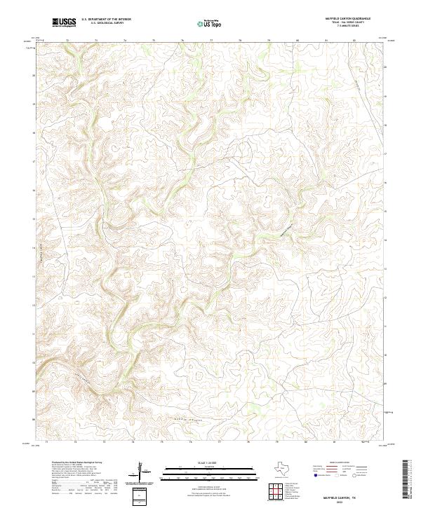
2022 Map of Mayfield Canyon
USGS Topo · Published 2022About this map
Mayfield Canyon and its surrounding drainage systems define the high plateau landscape of this portion of Val Verde County. The terrain is characterized by deeply incised watercourses and high ridges, illustrating the natural erosion patterns typical of the southwestern Texas borderlands. Apart from the isolated stretch of Ranch Rd 1024 in the northeast corner, the area is notably devoid of modern infrastructure, preserving a view of the land dominated by local topographic features such as Lewis Canyon and Gobble Canyon. This 2022 survey serves as a clear record of the physical geography and natural drainage basins, including Cold Water Canyon, within this sparsely settled ranching territory.
Find a feature on this map
5 named features on this map. Tap any name to fly to it.
Don’t see what you’re looking for? This feature index may not catch every label — zoom into the map to look around manually.
Map Details
Editions of this 2022 Mayfield Canyon Map
This is the sole edition of this map. No revisions or reprints were ever made.
Other maps of this area

1943 · Shumla
USGS Topo · 1:62,500

1944 · Baker Crossing
USGS Topo · 1:62,500

1954 · Sonora
USGS Topo · 1:250,000

1958 · Sonora
USGS Topo · 1:250,000

1958 · Del Rio
USGS Topo · 1:250,000

1964 · Del Rio
USGS Topo · 1:250,000

1970 · Everett Canyon
USGS Topo · 1:24,000

1970 · Sycamore Canyon
USGS Topo · 1:24,000

1970 · Blue Hills
USGS Topo · 1:24,000
1973 · Still Canyon
USGS Topo · 1:24,000