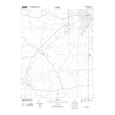
2010 Map of Mayfield
USGS Topo · Published 2010About this map
Mayfield serves as the regional hub for Graves County in the early 21st century, its grid expanding toward the Purchase Pkwy as modern infrastructure reshapes the traditional Kentucky landscape. The area south and west of the city remains deeply rooted in its agricultural and rural heritage, defined by a network of local roads such as Old Pryorsburg Rd and Ballard Rd. Small settlements like Pryorsburg and Wingo are linked by the winding courses of West Fork Mayfield Creek and Opossum Creek. Genealogists will find a wealth of local history preserved in numerous burial grounds scattered throughout the countryside, including Highland Park Cemetery, Saint Josephs Cemetery, and the Dodson Cemetery. From the shores of Sunset Lake to the outskirts of South Highland, the map documents a transition from established urban centers to the quiet, creek-fed terrain of western Kentucky.
Find a feature on this map
62 named features on this map. Tap any name to fly to it.
Don’t see what you’re looking for? This feature index may not catch every label — zoom into the map to look around manually.
Map Details
Editions of this 2010 Mayfield Map
This is the sole edition of this map. No revisions or reprints were ever made.
Other maps of this area

1936 · Farmington
USGS Topo · 1:24,000

1936 · Westplains
USGS Topo · 1:24,000

1951 · Farmington
USGS Topo · 1:24,000

1951 · Hickory
USGS Topo · 1:24,000
1951 · Westplains
USGS Topo · 1:24,000

1951 · Hickory
USGS Topo · 1:62,500

1952 · Mayfield
USGS Topo · 1:24,000

1952 · Dublin
USGS Topo · 1:24,000

1952 · Cuba
USGS Topo · 1:24,000

1952 · Fancy Farm
USGS Topo · 1:24,000