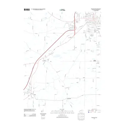
2013 Map of Mayfield
USGS Topo · Published 2013About this map
Pryorsburg and Wingo anchor this Graves County landscape, situated along a transportation corridor that includes the Purchase Pkwy N. This area of western Kentucky is characterized by a dense network of watercourses, with Obion Cr, Opossum Cr, and W Fork Mayfield Cr carving through the terrain. The presence of numerous burial grounds, such as Bethel Cem, Copeland Cem, and Saint Josephs Cem, provides a significant inventory for genealogical research, marking family and community history across the rural tracts between Payne and Stubblefield. Local landmarks like Sunset Lake and the Mayfield Memory Garden sit just outside the primary settlement hubs, while historical path names like Natchez Trce and Straight Church Rd hint at the established social and travel patterns of the region.
Find a feature on this map
36 named features on this map. Tap any name to fly to it.
Don’t see what you’re looking for? This feature index may not catch every label — zoom into the map to look around manually.
Map Details
Editions of this 2013 Mayfield Map
This is the sole edition of this map. No revisions or reprints were ever made.
Other maps of this area

1936 · Farmington
USGS Topo · 1:24,000

1936 · Westplains
USGS Topo · 1:24,000

1951 · Farmington
USGS Topo · 1:24,000

1951 · Hickory
USGS Topo · 1:24,000
1951 · Westplains
USGS Topo · 1:24,000

1951 · Hickory
USGS Topo · 1:62,500

1952 · Mayfield
USGS Topo · 1:24,000

1952 · Dublin
USGS Topo · 1:24,000

1952 · Cuba
USGS Topo · 1:24,000

1952 · Fancy Farm
USGS Topo · 1:24,000