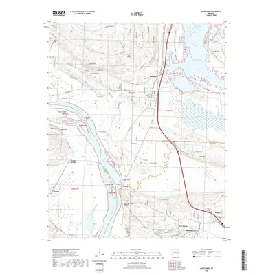
2020 Map of Mayflower
USGS Topo · Published 2020About this map
Mayflower sits at the junction of modern transit and older river corridors, marking a landscape where the Arkansas River and Lake Conway define the boundaries of Pulaski and Faulkner counties. The transition from the alluvial flats near Fletcher Bend to the elevated terrain of Mount Pilgrim and Reynolds Mtn is clearly visible. The Union Pacific Railroad and US Hwy 65 parallel the river, tracing a historic transportation spine that links settlements like Palarm and Morgan to the growing community of Maumelle in the south. Smaller features like Mayflower Cem and the Pine Village Airport offer specific points of interest for local history and genealogy. The map captures the complex hydrology of the area, from the wetlands of Bell Slough and Grassy Lake to the distinct curves of the river at Devils Bend.
Find a feature on this map
142 named features on this map. Tap any name to fly to it.
Don’t see what you’re looking for? This feature index may not catch every label — zoom into the map to look around manually.
Map Details
Editions of this 2020 Mayflower Map
This is the sole edition of this map. No revisions or reprints were ever made.
Other maps of this area

1890 · Benton
USGS Topo · 1:125,000

1891 · Little Rock
USGS Topo · 1:125,000

1892 · Morrillton
USGS Topo · 1:125,000

1893 · Little Rock
USGS Topo · 1:125,000

1894 · Morrillton
USGS Topo · 1:125,000

1894 · Benton
USGS Topo · 1:125,000

1935 · North Little Rock
USGS Topo · 1:24,000

1943 · Pinnacle Mtn
USGS Topo · 1:31,680

1953 · Cato
USGS Topo · 1:24,000

1953 · Mayflower
USGS Topo · 1:24,000