
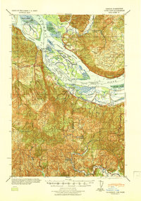
1919 Map of Mayger
USGS Topo · Published 1919About this map
The Columbia River dominates this military reconnaissance survey, serving as the central artery for a landscape defined by islands, sloughs, and early river-based settlements. Communities like Mayger and Quincy occupy the lowlands south of the river, while the S. P. & S. R. R. skirts the northern bank, marking the importance of rail transport alongside the water. The map documents the intricate drainage systems of Beaver Slough and Rinearsons Slough, features that would have been vital for early agricultural and industrial development in Columbia County.
Find a feature on this map
29 named features on this map. Tap any name to fly to it.
Don’t see what you’re looking for? This feature index may not catch every label — zoom into the map to look around manually.
Map Details
Editions of this 1919 Mayger Map
This is the sole edition of this map. No revisions or reprints were ever made.
Other maps of this area

1921 · Kalama
USGS Topo · 1:62,500

1922 · St. Helens
USGS Topo · 1:62,500

1940 · Vernonia
USGS Topo · 1:62,500

1941 · Keasey
USGS Topo · 1:62,500

1941 · St Helens
USGS Topo · 1:62,500

1941 · Olequa
USGS Topo · 1:62,500

1941 · Skamokawa
USGS Topo · 1:62,500

1941 · Clatskanie
USGS Topo · 1:62,500
1941 · Cathlamet
USGS Topo · 1:62,500
1943 · Vernonia
USGS Topo · 1:62,500