1987 Map of Maynard
USGS Topo · Published 1987About this map
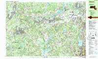
Concord and Maynard anchor this mid-1980s landscape, where the confluence of the Assabet River and Sudbury River forms the Concord River amidst a dense network of suburban development and historical preservation. The area is defined by its institutional and recreational landmarks, ranging from the military presence at Hanscom Air Force Base to the literary and natural legacy of Walden Pond State Res. Transportation patterns are clearly established by the Conrail and B & M railroad lines, which intersect with major arteries like State Highway 2 and the emerging corridor of Interstate 95.
Find a feature on this map
168 named features on this map. Tap any name to fly to it.
Don’t see what you’re looking for? This feature index may not catch every label — zoom into the map to look around manually.
Map Details
Editions of this 1987 Maynard Map
2 editions found

Other maps of this area

1886 · Lawrence
USGS Topo · 1:62,500

1886 · Lowell
USGS Topo · 1:62,500

1886 · Framingham
USGS Topo · 1:62,500

1887 · Marlboro
USGS Topo · 1:62,500

1888 · Lawrence
USGS Topo · 1:62,500

1889 · Marlboro
USGS Topo · 1:62,500

1889 · Framingham
USGS Topo · 1:62,500

1893 · Lowell
USGS Topo · 1:62,500

1893 · Boston
USGS Topo · 1:62,500

1893 · Lawrence
USGS Topo · 1:62,500