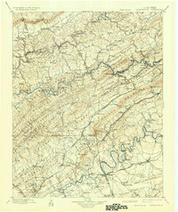
1900 Map of Maynardville
USGS Topo · Published 1935About this map
Maynardville and Tazewell anchor this landscape of the East Tennessee valley and ridge system, mapped during the final decade of the nineteenth century. The region is defined by the parallel courses of the Clinch River, Powell River, and Holston River, which carve through prominent elevations like Clinch Mountain and Wallens Ridge. Before the era of modern bridges, numerous river crossings such as Needham Ford and Walkers Ford facilitated local commerce between small communities like Sharps Chapel and Liberty Hill.
Find a feature on this map
181 named features on this map. Tap any name to fly to it.
Don’t see what you’re looking for? This feature index may not catch every label — zoom into the map to look around manually.
Map Details
Editions of this 1900 Maynardville Map
4 editions found

Other maps of this area

1883 · Morristown
USGS Topo · 1:125,000

1886 · Knoxville
USGS Topo · 1:125,000

1886 · Cumberland Gap
USGS Topo · 1:125,000

1887 · Jonesville
USGS Topo · 1:125,000

1888 · Cumberland Gap
USGS Topo · 1:125,000

1890 · Williamsburg
USGS Topo · 1:125,000

1891 · Cumberland Gap
USGS Topo · 1:125,000

1891 · Jonesville
USGS Topo · 1:125,000

1892 · Knoxville
USGS Topo · 1:125,000

1893 · Mt Guyot
USGS Topo · 1:125,000