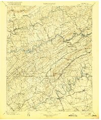
1900 Map of Maynardville
USGS Topo · Published 1921About this map
Cumberland Mountain and the parallel ridges of East Tennessee dominate this landscape as it appeared at the turn of the century. The map illustrates a region defined by its water crossings and mountain passes, where the Powell River, Clinch River, and Holston River carve through a succession of ridges including Chestnut Ridge and Copper Ridge. Numerous river crossings like Walkers Ford, Black Fox Ford, and Swett Ford indicate the vital transport network before modern bridging.
Find a feature on this map
172 named features on this map. Tap any name to fly to it.
Don’t see what you’re looking for? This feature index may not catch every label — zoom into the map to look around manually.
Map Details
Editions of this 1900 Maynardville Map
4 editions found

Other maps of this area

1883 · Morristown
USGS Topo · 1:125,000

1886 · Knoxville
USGS Topo · 1:125,000

1886 · Cumberland Gap
USGS Topo · 1:125,000

1887 · Jonesville
USGS Topo · 1:125,000

1888 · Cumberland Gap
USGS Topo · 1:125,000

1890 · Williamsburg
USGS Topo · 1:125,000

1891 · Cumberland Gap
USGS Topo · 1:125,000

1891 · Jonesville
USGS Topo · 1:125,000

1892 · Knoxville
USGS Topo · 1:125,000

1893 · Mt Guyot
USGS Topo · 1:125,000