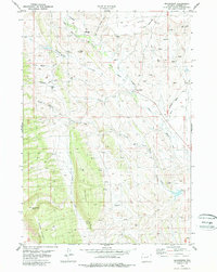
1979 Map of Mayoworth
USGS Topo · Published 1987About this map
Mayoworth serves as the focal point of this ranching and drainage basin in Johnson County, situated where the Mayoworth Slope meets the varied terrain of The Mesa and Lander Hill. The map reveals a complex irrigation network vital to the high plains, featuring the Captola Ditch, Strickler Rinker Ditch, and Bob Brock Ditch which divert water from the North Fork Powder River. This system of managed water, including the Pass Reservoir and numerous Springs and Flowing Wells, underscores the human adaptation to the semi-arid landscape east of the Bighorn Mountains.
Find a feature on this map
37 named features on this map. Tap any name to fly to it.
Don’t see what you’re looking for? This feature index may not catch every label — zoom into the map to look around manually.
Map Details
Editions of this 1979 Mayoworth Map
This is the sole edition of this map. No revisions or reprints were ever made.
Other maps of this area

1955 · Arminto
USGS Topo · 1:250,000

1958 · Arminto
USGS Topo · 1:250,000

1961 · Barnum
USGS Topo · 1:62,500

1961 · Schlict Draw
USGS Topo · 1:24,000

1961 · Hibbard Draw
USGS Topo · 1:24,000

1961 · Kaycee
USGS Topo · 1:24,000

1962 · Arminto
USGS Topo · 1:250,000

1963 · Mayoworth
USGS Topo · 1:62,500
1979 · Red Fork Powder River
USGS Topo · 1:24,000
1984 · Fraker Mountain
USGS Topo · 1:24,000