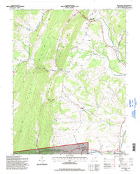
1995 Map of Maysville
USGS Topo · Published 1998About this map
Knobly Mountain dominates the western half of this Grant County landscape, providing a formidable geological backdrop to the valley communities. In the mid-1990s, the rural character of the region remains intact, anchored by Maysville at the junction of the North Fork and South Fork of Lunice Creek. The map reveals a community defined by its proximity to the Monongahela National Forest and the Spruce Knob - Seneca Rocks Recreation Area to the south. Local landmarks like the Gospel Tabernacle and Harmony Ch provide touchpoints for genealogists, while more modern developments such as the Drive-in Theater near Petersburg indicate shifting local leisure patterns. Narrow gaps like Real Gap and Kline Gap serve as the primary conduits through the ridges, concentrating historical travel and settlement along their routes.
Find a feature on this map
43 named features on this map. Tap any name to fly to it.
Don’t see what you’re looking for? This feature index may not catch every label — zoom into the map to look around manually.
Map Details
Editions of this 1995 Maysville Map
This is the sole edition of this map. No revisions or reprints were ever made.
Other maps of this area

1892 · Franklin
USGS Topo · 1:125,000

1895 · Piedmont
USGS Topo · 1:125,000

1896 · Franklin
USGS Topo · 1:125,000

1916 · Davis
USGS Topo · 1:48,000

1918 · Davis
USGS Topo · 1:62,500

1919 · Davis
USGS Topo · 1:62,500

1920 · Davis
USGS Topo · 1:48,000

1920 · Petersburg
USGS Topo · 1:48,000

1920 · Onego
USGS Topo · 1:62,500

1921 · Petersburg
USGS Topo · 1:48,000