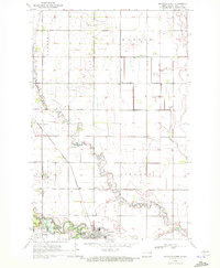
1970 Map of Mayville North
USGS Topo · Published 1972About this map
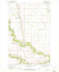
Mayville State College anchors the southern portion of this Traill County landscape, where the academic grounds meet the developed edge of Mayville. This 1970s survey captures the region's agricultural and transportation infrastructure, defined by the winding course of the North Branch Goose River and the Goose River. The Burlington Northern railroad serves as a primary transit corridor, passing through Portland Junction and the town of Portland. The rural survey areas of Garfield, Morgan, and Lindaas show a grid of section lines dotted with family heritage sites such as Holmes Cem and Morgan Cem. Leisure and utility coexist at the edge of town near the Mayville Golf Course, illustrating the local community's spatial organization during this era of North Dakota history.
Find a feature on this map
13 named features on this map. Tap any name to fly to it.
Don’t see what you’re looking for? This feature index may not catch every label — zoom into the map to look around manually.
Map Details
Editions of this 1970 Mayville North Map
This is the sole edition of this map. No revisions or reprints were ever made.
Other maps of this area

1918 · Kelso
USGS Topo · 1:62,500

1943 · Kelso
USGS Topo · 1:62,500

1952 · Grand Forks
USGS Topo · 1:250,000

1956 · Grand Forks
USGS Topo · 1:250,000

1966 · Grand Forks
USGS Topo · 1:250,000

1967 · Mayville South
USGS Topo · 1:24,000
1967 · Hillsboro NW
USGS Topo · 1:24,000
1968 · Galesburg NW
USGS Topo · 1:24,000
1970 · Hatton
USGS Topo · 1:24,000
1970 · Hatton SW
USGS Topo · 1:24,000