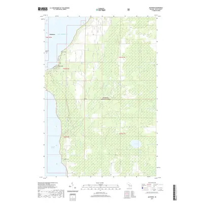
2019 Map of Maywood
USGS Topo · Published 2019About this map
Gladstone and the community of Maywood sit along the western edge of the Stonington Peninsula, overlooking the waters of Little Bay de Noc. This Upper Peninsula landscape is defined by the expansive Hiawatha National Forest, where a network of drainages including Squaw Creek and Misery Creek flow through the timberland toward Lake Michigan. The map details the transitional area between the established shoreline settlements and the interior forest, featuring recreational routes like the Bayshore Trail and White Pine Trail. Genealogists and local historians can locate established burial grounds such as Bay De Noc Cemetery and Lakewood Cemetery, while the shoreline is marked by distinct landforms like Saunders Point and Hunters Point. To the southeast, the interior woods are dotted with isolated water bodies including Lake Sixteen and Lake Little Sixteen.
Find a feature on this map
24 named features on this map. Tap any name to fly to it.
Don’t see what you’re looking for? This feature index may not catch every label — zoom into the map to look around manually.
Map Details
Editions of this 2019 Maywood Map
This is the sole edition of this map. No revisions or reprints were ever made.
Other maps of this area

1932 · Gladstone NE
USGS Topo · 1:31,680

1932 · Rapid River NE
USGS Topo · 1:31,680

1932 · Gladstone SE
USGS Topo · 1:31,680

1932 · Rapid River NW
USGS Topo · 1:31,680

1932 · Rapid River SE
USGS Topo · 1:31,680

1932 · Rapid River SW
USGS Topo · 1:31,680

1954 · Escanaba
USGS Topo · 1:250,000

1957 · Escanaba
USGS Topo · 1:250,000

1958 · Escanaba
USGS Topo · 1:250,000

1958 · Gladstone
USGS Topo · 1:62,500