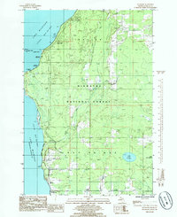
1985 Map of Maywood
USGS Topo · Published 1985About this map
Little Bay De Noc dominates the western shoreline of this Delta County peninsula, where the small settlement of Maywood sits at the water's edge. The interior is largely defined by the protected landscape of the Hiawatha National Forest, interspersed with small lakes like Lake Sixteen and Little Lake Sixteen. This 1980s-era record reveals a quiet coastal community centered around the Stonington Community Hall and Township Hall, with local genealogy interests anchored at Lakewood Cem. Along the coast, Saunders Point and Hunters Point mark the transition from sandy beaches to wooded uplands, while the presence of Slab Dock Campground and Maywood Campground suggests a shift toward seasonal recreation in this Upper Peninsula landscape. Narrow drainage systems like Squaw Creek and Misery Creek wind through the forest, illustrating the natural water table before modern development patterns fully altered the terrain.
Find a feature on this map
24 named features on this map. Tap any name to fly to it.
Don’t see what you’re looking for? This feature index may not catch every label — zoom into the map to look around manually.
Map Details
Editions of this 1985 Maywood Map
This is the sole edition of this map. No revisions or reprints were ever made.
Other maps of this area

1932 · Gladstone NE
USGS Topo · 1:31,680

1932 · Rapid River NE
USGS Topo · 1:31,680

1932 · Gladstone SE
USGS Topo · 1:31,680

1932 · Rapid River NW
USGS Topo · 1:31,680

1932 · Rapid River SE
USGS Topo · 1:31,680

1932 · Rapid River SW
USGS Topo · 1:31,680

1954 · Escanaba
USGS Topo · 1:250,000

1957 · Escanaba
USGS Topo · 1:250,000

1958 · Escanaba
USGS Topo · 1:250,000

1958 · Gladstone
USGS Topo · 1:62,500