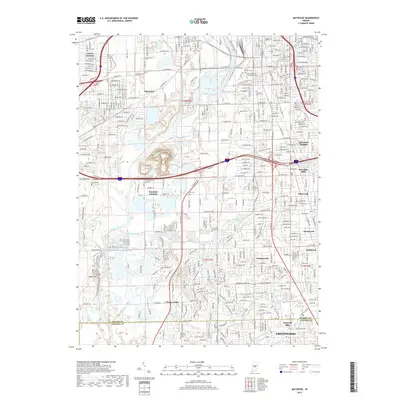
2019 Map of Maywood
USGS Topo · Published 2019About this map
The White River and its intricate network of tributaries, including Lick Creek, Little Buck Creek, and Harmon Ditch, define the suburban and industrial character of southern Indianapolis. This 2019 survey documents a landscape of dense residential developments like Drexel Gardens and Sunshine Gardens alongside significant industrial and transportation corridors. The map records a concentration of large burial grounds, such as Calvary Cem, Concordia Cem, and Holy Cross and Saint Joseph Cem, which serve as anchor points for local history and genealogy. Southward, the terrain transitions at the Marion County and Johnson County line, where the suburban grid of Greenwood and Southport meets the more open spaces near Glenns Valley. Researchers can trace the sophisticated water management systems represented by the numerous named ditches and runs, such as Hauelsen Ditch and Thompson Run, that support this well-developed metropolitan area.
Find a feature on this map
93 named features on this map. Tap any name to fly to it.
Don’t see what you’re looking for? This feature index may not catch every label — zoom into the map to look around manually.
Map Details
Editions of this 2019 Maywood Map
This is the sole edition of this map. No revisions or reprints were ever made.
Other maps of this area

1948 · Indianapolis East
USGS Topo · 1:24,000

1948 · Maywood
USGS Topo · 1:24,000

1948 · Beech Grove
USGS Topo · 1:24,000

1948 · Indianapolis West
USGS Topo · 1:24,000

1952 · Bargersville
USGS Topo · 1:24,000

1953 · Greenwood
USGS Topo · 1:24,000

1953 · Bridgeport
USGS Topo · 1:24,000

1953 · Clermont
USGS Topo · 1:24,000

1953 · Indianapolis
USGS Topo · 1:250,000

1955 · Mooresville East
USGS Topo · 1:24,000
Featured Places
- Indianapolis, IN
- Greenwood, IN
- Southport, Indianapolis
- Homecroft, Indianapolis
- Glenns Valley, Indianapolis