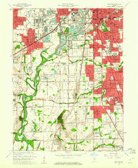
1959 Map of Maywood
USGS Topo · Published 1961About this map
The White River corridor serves as the industrial and logistical spine for South Indianapolis and northern Johnson County in this late-1950s survey. Extensive development defines the northern half of the sheet, where the Union Stockyards and a massive Sewage Disposal facility sit near the river's bend, while Stout Field anchors the northwest corner. This period captures a landscape transitioning from heavy industry and aviation to suburban expansion, most notably in the growing residential pockets of Mars Hill and Drexel Gardens.
Find a feature on this map
80 named features on this map. Tap any name to fly to it.
Don’t see what you’re looking for? This feature index may not catch every label — zoom into the map to look around manually.
Map Details
Editions of this 1959 Maywood Map
This is the sole edition of this map. No revisions or reprints were ever made.
Other maps of this area

1948 · Indianapolis East
USGS Topo · 1:24,000

1948 · Maywood
USGS Topo · 1:24,000

1948 · Beech Grove
USGS Topo · 1:24,000

1948 · Indianapolis West
USGS Topo · 1:24,000

1952 · Bargersville
USGS Topo · 1:24,000

1953 · Greenwood
USGS Topo · 1:24,000

1953 · Bridgeport
USGS Topo · 1:24,000

1953 · Clermont
USGS Topo · 1:24,000

1953 · Indianapolis
USGS Topo · 1:250,000

1955 · Mooresville East
USGS Topo · 1:24,000
Featured Places
- Indianapolis, IN
- Greenwood, IN
- Southport, Indianapolis
- Homecroft, Indianapolis
- Drexel Gardens, Indianapolis