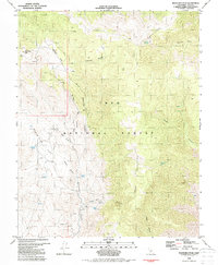
1982 Map of Mazourka Peak
USGS Topo · Published 1987About this map
Mazourka Peak dominates the western edge of this 1982 survey, serving as a high-altitude focal point for a remote landscape defined by steep drainages and scattered mineral prospects. Most of the territory falls within the Inyo National Forest, where the rugged Inyo Mountains are carved by deep cuts like Mazourka Canyon and Waucoba Canyon. The industrial character of the early 1980s is visible in the network of 4wd tracks that crisscross the high desert terrain to reach isolated mining sites and the Radio Facility at the peak.
Find a feature on this map
38 named features on this map. Tap any name to fly to it.
Don’t see what you’re looking for? This feature index may not catch every label — zoom into the map to look around manually.
Map Details
Editions of this 1982 Mazourka Peak Map
2 editions found
Other maps of this area

1907 · Mt. Whitney
USGS Topo · 1:125,000

1908 · Lida
USGS Topo · 1:250,000

1908 · Ballarat
USGS Topo · 1:250,000

1913 · Bishop
USGS Topo · 1:125,000

1913 · Lida
USGS Topo · 1:250,000

1913 · Ballarat
USGS Topo · 1:250,000

1919 · Mt. Whitney
USGS Topo · 1:125,000

1937 · Mt. Whitney
USGS Topo · 1:125,000

1947 · Mariposa
USGS Topo · 1:250,000

1948 · Death Valley
USGS Topo · 1:250,000