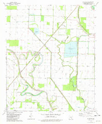
1981 Map of Mc Arthur
USGS Topo · Published 1982About this map
McArthur sits at the heart of this Arkansas Delta landscape, where the sinuous curves of Bayou Macon and Little Bayou Macon dominate the terrain. The region’s agricultural character is evidenced by an extensive network of drainage features such as Coon Bayou, Boggy Slough, and Big Boggy Slough, alongside large irrigation reservoirs. The Missouri Pacific Railroad cuts a diagonal path through the quadrangle, serving as a primary transportation artery through the alluvial flats. Local heritage is concentrated in small rural pockets, specifically around community anchors like Mt Zion Church and Palestine Church, each with its own associated burial ground. To the south, the edge of the McGehee Municipal Airport and a Radio Tower signal the transition toward more modern infrastructure, while the presence of a Sandpit and Industrial labeling highlights the area's resource extraction and utility.
Find a feature on this map
25 named features on this map. Tap any name to fly to it.
Don’t see what you’re looking for? This feature index may not catch every label — zoom into the map to look around manually.
Map Details
Editions of this 1981 Mc Arthur Map
This is the sole edition of this map. No revisions or reprints were ever made.
Other maps of this area

1933 · Lamont
USGS Topo · 1:62,500

1935 · Red Fork
USGS Topo · 1:62,500

1936 · McGehee
USGS Topo · 1:62,500

1937 · McGehee
USGS Topo · 1:62,500

1939 · Big Island
USGS Topo · 1:62,500

1939 · Lamont
USGS Topo · 1:62,500

1953 · Greenwood
USGS Topo · 1:250,000

1955 · McGehee
USGS Topo · 1:62,500

1956 · Greenwood
USGS Topo · 1:250,000
1969 · Winchester
USGS Topo · 1:24,000