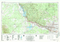
1983 Map of Mc Allen
USGS Topo · Published 1984About this map
The Rio Grande and its Mexican counterpart, the Río Bravo, form the central axis of this international landscape, which captures the development of the Rio Grande Valley in the early 1980s. Large-scale water management projects dominate the region, including the massive Falcon Lake and its associated dam at Falcon Village, as well as the Presa Marte R. Gómez to the south. Along the American bank, the agricultural and urban corridor stretching from Mission and Mc Allen through Edinburg and Weslaco shows a dense network of irrigation and infrastructure served by the Southern Pacific railroad.
Find a feature on this map
62 named features on this map. Tap any name to fly to it.
Don’t see what you’re looking for? This feature index may not catch every label — zoom into the map to look around manually.
Map Details
Editions of this 1983 Mc Allen Map
This is the sole edition of this map. No revisions or reprints were ever made.
Other maps of this area

1914 · San Juan
USGS Topo · 1:48,000

1916 · San Juan
USGS Topo · 1:62,500

1921 · Falfurrias
USGS Topo · 1:125,000

1922 · La Sal Vieja
USGS Topo · 1:62,500

1923 · Armstrong
USGS Topo · 1:62,500

1928 · Sarita
USGS Topo · 1:125,000

1938 · Falcon
USGS Topo · 1:62,500

1938 · El Sauz
USGS Topo · 1:62,500

1938 · Agua Nueva
USGS Topo · 1:62,500

1938 · Sal Colorada
USGS Topo · 1:62,500