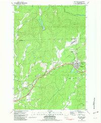
1981 Map of Mc Cleary
USGS Topo · Published 1981About this map
McCleary serves as the primary hub in this Grays Harbor County landscape, situated near the transition from Monkeys Prairie into the densely forested Black Hills. This 1981 survey reveals a cluster of timber and transit settlements including Garden City, Rayville, and Whites, all oriented along the Burlington Northern railroad line. The presence of the Mark E Reed Memorial Hospital and a Grange Hall suggests a well-established community infrastructure supporting the local population.
Find a feature on this map
35 named features on this map. Tap any name to fly to it.
Don’t see what you’re looking for? This feature index may not catch every label — zoom into the map to look around manually.
Map Details
Editions of this 1981 Mc Cleary Map
This is the sole edition of this map. No revisions or reprints were ever made.
Other maps of this area

1939 · Shelton
USGS Topo · 1:62,500

1941 · Gate
USGS Topo · 1:62,500

1941 · Ford
USGS Topo · 1:62,500

1943 · Nahwatzel Lake
USGS Topo · 1:62,500

1953 · Hoquiam
USGS Topo · 1:250,000

1953 · Rochester
USGS Topo · 1:62,500

1953 · Malone
USGS Topo · 1:62,500

1953 · Shelton
USGS Topo · 1:62,500

1953 · Elma
USGS Topo · 1:62,500

1957 · Hoquiam
USGS Topo · 1:250,000