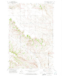
1972 Map of Mc Cone Heights
USGS Topo · Published 1975About this map
Mc Cone Heights and the surrounding high plains of eastern Montana dominate this topographic study, captured shortly after 1970 aerial photography. The landscape is defined by the sharp transition between the flat, elevated surface of Butler Table and the intricate drainage networks carved by Crane Creek and Dunlap Creek. This area, straddling the border of Richland and Dawson counties, showcases the complex erosion patterns characteristic of the region, where numerous wells are scattered across the section lines to support cattle ranching on the high divides. The presence of Chimney Rock provides a distinct vertical landmark amidst the dissected coulees of the North Fork Burns Creek drainage, illustrating the geological character of the Missouri River breaks country during this era of stable ranching and land use.
Find a feature on this map
9 named features on this map. Tap any name to fly to it.
Don’t see what you’re looking for? This feature index may not catch every label — zoom into the map to look around manually.
Map Details
Editions of this 1972 Mc Cone Heights Map
This is the sole edition of this map. No revisions or reprints were ever made.
Other maps of this area

1909 · Glendive
USGS Topo · 1:250,000

1954 · Glendive
USGS Topo · 1:250,000

1957 · Glendive
USGS Topo · 1:250,000

1958 · Glendive
USGS Topo · 1:250,000

1966 · Crane NW
USGS Topo · 1:24,000

1966 · Knife River Mine
USGS Topo · 1:24,000

1966 · Intake NW
USGS Topo · 1:24,000

1966 · Allard Ranch
USGS Topo · 1:24,000

1966 · Larson School
USGS Topo · 1:24,000

1972 · Butler Table
USGS Topo · 1:24,000