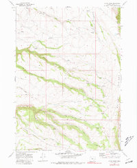
1968 Map of Mc Coy Ridge
USGS Topo · Published 1981About this map
Steens Mountain and Mc Coy Ridge dominate this high-desert landscape in Harney County, where water is the primary driver of human presence. Named cabins and homesteads, including Catherson Cabin, Patterson Cabin, and the Glen Brown Place, are scattered along the canyons and springs, indicating a history of seasonal ranching and rugged land use. The drainage network is complex, defined by the headwaters of Krumbo Creek, Big Bridge Creek, and Big Fir Creek. Man-made water management is evident through numerous reservoirs such as Antelope Reservoir, Witzel Reservoir, and Sagehen Reservoir. A network of jeep trails and fences crisscrosses the terrain, marking the boundaries of range land and providing access to remote springs and high-elevation basins.
Find a feature on this map
30 named features on this map. Tap any name to fly to it.
Don’t see what you’re looking for? This feature index may not catch every label — zoom into the map to look around manually.
Map Details
Editions of this 1968 Mc Coy Ridge Map
3 editions found
Other maps of this area

1955 · Adel
USGS Topo · 1:250,000

1957 · Adel
USGS Topo · 1:250,000

1958 · Adel
USGS Topo · 1:250,000

1962 · Adel
USGS Topo · 1:250,000

1967 · Krumbo Reservoir
USGS Topo · 1:24,000

1967 · Page Springs
USGS Topo · 1:24,000

1968 · Poison Springs
USGS Topo · 1:24,000

1968 · Tombstone Canyon
USGS Topo · 1:24,000

1968 · Fish Lake
USGS Topo · 1:24,000

1968 · Wildhorse Lake
USGS Topo · 1:24,000