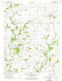
1973 Map of Mc Cune
USGS Topo · Published 1975About this map
The Neosho River meanders through the western half of this Kansas landscape, defining a wide floodplain that contrasts with the surrounding agricultural uplands. Near the river, industrial activity is marked by a Power Plant, a Gaging Station, and the presence of Service Lake. To the north, the town of Mc Cune serves as a local hub, situated at the junction of the St Louis - San Francisco railroad and the intersection of Crawford and Cherokee counties.
Find a feature on this map
30 named features on this map. Tap any name to fly to it.
Don’t see what you’re looking for? This feature index may not catch every label — zoom into the map to look around manually.
Map Details
Editions of this 1973 Mc Cune Map
This is the sole edition of this map. No revisions or reprints were ever made.
Other maps of this area

1886 · Joplin
USGS Topo · 1:125,000

1886 · Parsons
USGS Topo · 1:125,000

1893 · Parsons
USGS Topo · 1:125,000

1894 · Joplin
USGS Topo · 1:125,000

1918 · Columbus
USGS Topo · 1:62,500

1943 · McCune
USGS Topo · 1:62,500

1943 · Cherokee
USGS Topo · 1:62,500

1944 · Oswego
USGS Topo · 1:62,500

1945 · Mc Cune
USGS Topo · 1:62,500

1945 · Cherokee
USGS Topo · 1:62,500