
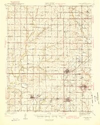
1945 Map of Cherokee
USGS Topo · Published 1945About this map
Strip Mines dominate the southeastern quadrant of this landscape, illustrating the intensive coal extraction industry that shaped the economy of Crawford and Cherokee Counties during the mid-1940s. A dense network of rail lines, including the St Louis San Francisco RR and the Missouri Kansas Texas RR, crisscrosses the terrain to serve mining hubs like Cherokee, Weir, and Scammon. The map reveals a highly organized rural society, with one-room schoolhouses such as Cyclone Sch, Harmony Sch, and Skidmore Sch 19 placed at regular intervals for the farming and mining families. Local landmarks like the County Farm and State Quail Farm appear alongside numerous cemeteries, including Cherokee City Cem and Sacred Heart Cem, providing a detailed record of the region's civic and genealogical history at the end of the war years.
Find a feature on this map
75 named features on this map. Tap any name to fly to it.
Don’t see what you’re looking for? This feature index may not catch every label — zoom into the map to look around manually.
Map Details
Editions of this 1945 Cherokee Map
2 editions found
Other maps of this area

1884 · Fort Scott
USGS Topo · 1:125,000

1886 · Joplin
USGS Topo · 1:125,000

1886 · Iola
USGS Topo · 1:125,000

1886 · Fort Scott
USGS Topo · 1:125,000

1886 · Parsons
USGS Topo · 1:125,000

1893 · Fort Scott
USGS Topo · 1:125,000

1893 · Iola
USGS Topo · 1:125,000

1893 · Parsons
USGS Topo · 1:125,000

1894 · Joplin
USGS Topo · 1:125,000

1904 · Iola
USGS Topo · 1:125,000