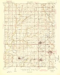
1945 Map of Cherokee
USGS Topo · Published 1945About this map
Strip mines dominate the landscape of Crawford and Cherokee counties in this mid-1940s survey, revealing a region defined by industrial coal extraction. The dense network of the St Louis San Francisco RR, Missouri Pacific RR, and Atchison Topeka and Santa Fe RR weaves between towns like West Mineral, Scammon, and Weir, illustrating the vital connection between rail and the mining economy. Notable local landmarks include the Immaculate Conception Ch and numerous rural schools such as Cyclone Sch and Skidmore Sch 19. The map also captures the transition from agriculture to industry, with the State Qual Farm and County Farm Cem situated near expanding excavation areas. Water features like Lightning Creek and Mineral Lake provide the drainage for this heavily modified terrain during a period of peak production.
Find a feature on this map
79 named features on this map. Tap any name to fly to it.
Don’t see what you’re looking for? This feature index may not catch every label — zoom into the map to look around manually.
Map Details
Editions of this 1945 Cherokee Map
2 editions found

Other maps of this area

1884 · Fort Scott
USGS Topo · 1:125,000

1886 · Joplin
USGS Topo · 1:125,000

1886 · Iola
USGS Topo · 1:125,000

1886 · Fort Scott
USGS Topo · 1:125,000

1886 · Parsons
USGS Topo · 1:125,000

1893 · Fort Scott
USGS Topo · 1:125,000

1893 · Iola
USGS Topo · 1:125,000

1893 · Parsons
USGS Topo · 1:125,000

1894 · Joplin
USGS Topo · 1:125,000

1904 · Iola
USGS Topo · 1:125,000