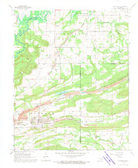
1968 Map of Mc Curtain
USGS Topo · Published 1970About this map
McCurtain and Ironbridge anchor this industrial landscape during a period of transition for the local topography. In the north, blue hatching marks the impending expansion of the Robert S Kerr Reservoir into the Sans Bois Creek valley. The map documents an economy rooted in extraction, visible through numerous Strip Mines, Quarries, and prolific gas wells scattered across the Sans Bois Mountain and Campground Mountain ridges. Transportation patterns are clearly defined by the Fort Smith And Van Buren corridor and an Old Railroad Grade passing south of town. For genealogists, the map preserves the locations of local landmarks like the Garden of Memories Cem, Mt Olive Ch, and Center Point Ch, providing a precise look at the community before the reservoir reached its full elevation.
Find a feature on this map
29 named features on this map. Tap any name to fly to it.
Don’t see what you’re looking for? This feature index may not catch every label — zoom into the map to look around manually.
Map Details
Editions of this 1968 Mc Curtain Map
2 editions found
Other maps of this area

1900 · Sansbois
USGS Topo · 1:125,000

1900 · Sallisaw
USGS Topo · 1:125,000

1909 · Sans Bois
USGS Topo · 1:125,000

1911 · Sallisaw
USGS Topo · 1:125,000

1911 · Sansbois
USGS Topo · 1:125,000

1946 · Fort Smith
USGS Topo · 1:250,000

1962 · Stigler East
USGS Topo · 1:24,000

1965 · Fort Smith
USGS Topo · 1:250,000

1967 · Fort Smith
USGS Topo · 1:250,000
1967 · Keota
USGS Topo · 1:24,000