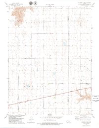
1978 Map of Mc Donald SW
USGS Topo · Published 1979About this map
The High Plains of Cheyenne County are characterized here by a distinct township-and-range grid, where small cemeteries like Evergreen Cem and Grace Cem mark the heritage of early rural communities. The southern portion of the quadrangle is defined by the Burlington Northern railroad corridor, a vital transport link for the region's agricultural economy. This section of Kansas, including portions of Evergreen, Bird City, and Burntwood townships, shows a landscape dotted with numerous water wells and seasonal drainage patterns such as North Beaver Cr. The map reveals how the border between Cheyenne and Rawlins counties was surveyed across this predominantly open prairie, reflecting the late 20th-century land use patterns before modern pivots altered the visual character of the plains.
Find a feature on this map
10 named features on this map. Tap any name to fly to it.
Don’t see what you’re looking for? This feature index may not catch every label — zoom into the map to look around manually.
Map Details
Editions of this 1978 Mc Donald SW Map
This is the sole edition of this map. No revisions or reprints were ever made.
Other maps of this area

1950 · Mc Donald
USGS Topo · 1:62,500

1951 · Bird City North
USGS Topo · 1:62,500

1951 · Mc Donald
USGS Topo · 1:62,500

1951 · Bird City South
USGS Topo · 1:62,500

1951 · Dewey Ranch
USGS Topo · 1:62,500

1954 · Goodland
USGS Topo · 1:250,000

1956 · Goodland
USGS Topo · 1:250,000

1957 · Goodland
USGS Topo · 1:250,000

1976 · Bird City North
USGS Topo · 1:24,000
1976 · Henkle Canyon
USGS Topo · 1:24,000