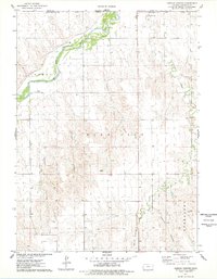
1976 Map of Henkle Canyon
USGS Topo · Published 1978About this map
The South Fork Republican River winds across the northwestern corner of this Cheyenne County landscape, defining a fertile corridor against the dissected uplands of the High Plains. Small settlements like Lowe and Flemming appear as quiet rural anchors amidst a complex network of drainages including Henkle Canyon and Sleepy Canyon. The terrain is deeply grooved by water, with Big Timber Creek, Devils Canyon, and Wolfe Canyon carving distinct paths toward the river basin. Landmarks such as Mt Hope and the Evergreen area provide specific points of reference within the Bird City and Calhoun townships. This 1970s survey illustrates a region shaped by agricultural life and natural erosion, where the Kansas-Nebraska border meets at the Base Line.
Find a feature on this map
18 named features on this map. Tap any name to fly to it.
Don’t see what you’re looking for? This feature index may not catch every label — zoom into the map to look around manually.
Map Details
Editions of this 1976 Henkle Canyon Map
This is the sole edition of this map. No revisions or reprints were ever made.
Other maps of this area

1950 · Mc Donald
USGS Topo · 1:62,500

1951 · Bird City North
USGS Topo · 1:62,500

1951 · Mc Donald
USGS Topo · 1:62,500

1954 · McCook
USGS Topo · 1:250,000

1954 · Goodland
USGS Topo · 1:250,000

1956 · Goodland
USGS Topo · 1:250,000

1957 · McCook
USGS Topo · 1:250,000

1957 · Goodland
USGS Topo · 1:250,000

1958 · McCook
USGS Topo · 1:250,000
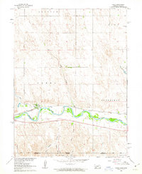
1961 · Parks
USGS Topo · 1:24,000