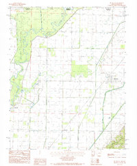
1984 Map of Mc Dougal
USGS Topo · Published 1984About this map
Crowleys Ridge rises in the southeast corner of this landscape, providing a sharp elevation contrast to the low-lying alluvial plains shaped by the Black River. This 1984 survey documents the state line between Missouri and Arkansas, specifically where Butler County and Clay County meet. The area is defined by its water systems and rural settlements, including McDougal, Hickoria, and Cantwell. A network of drainage ditches and canals, such as the Little Cache River and Cane Creek, crisscrosses the agricultural land between the river and the ridge. Local historians can find several small Cemeteries throughout the territory, marking the distribution of late 20th-century rural residency before further modern consolidation. The map preserves the specific irrigation and transport patterns of this border region as it appeared in the mid-1980s.
Find a feature on this map
10 named features on this map. Tap any name to fly to it.
Don’t see what you’re looking for? This feature index may not catch every label — zoom into the map to look around manually.
Map Details
Editions of this 1984 Mc Dougal Map
This is the sole edition of this map. No revisions or reprints were ever made.
Other maps of this area

1935 · Acorn
USGS Topo · 1:62,500

1935 · Rector
USGS Topo · 1:62,500

1935 · Knobel
USGS Topo · 1:62,500

1935 · Harviell
USGS Topo · 1:62,500

1940 · Naylor
USGS Topo · 1:62,500

1941 · Knobel
USGS Topo · 1:62,500

1944 · Naylor
USGS Topo · 1:62,500

1957 · Poplar Bluff
USGS Topo · 1:250,000

1958 · Rector
USGS Topo · 1:62,500

1959 · Poplar Bluff
USGS Topo · 1:250,000