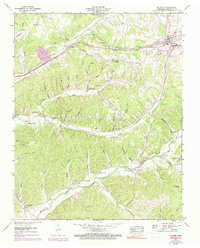
1952 Map of Mc Ewen
USGS Topo · Published 1990About this map
McEwen and the nearby village of Gorman serve as the primary anchors for this mid-century portrait of Humphreys County, defined by the east-west corridor of the Louisville And Nashville railroad. This transportation spine, paralleled by the Louisville And Nashville Broadway Of America, cuts through a landscape of deeply etched hollows such as Choate Hollow and Dunn Hollow. The map reveals a densely settled rural society where community life centered on local institutions like Liberty Sch and numerous country sanctuaries, including New Bethel Ch and Providence Ch. For genealogists, the map is particularly rich in family-named landmarks and burial grounds, ranging from the Anderson Cem to the McCollum Cem. In the northwest, the Humphreys County Airfield near Little Richland Creek marks the early post-war expansion of local infrastructure into the rural landscape.
Find a feature on this map
73 named features on this map. Tap any name to fly to it.
Don’t see what you’re looking for? This feature index may not catch every label — zoom into the map to look around manually.
Map Details
Editions of this 1952 Mc Ewen Map
3 editions found
Other maps of this area

1936 · Gorman
USGS Topo · 1:24,000

1936 · Hurricane Mills
USGS Topo · 1:24,000

1936 · Woolworth
USGS Topo · 1:24,000

1936 · Ruskin
USGS Topo · 1:24,000

1936 · Bucksnort
USGS Topo · 1:24,000

1936 · Halls Creek
USGS Topo · 1:24,000

1936 · Spot
USGS Topo · 1:24,000

1936 · Waverly
USGS Topo · 1:24,000

1936 · Tennessee City
USGS Topo · 1:24,000

1950 · Halls Creek
USGS Topo · 1:24,000