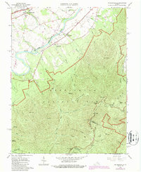
1965 Map of Mc Gaheysville
USGS Topo · Published 1987About this map
The South Fork Shenandoah River winds through the northern half of this map, serving as a primary corridor for the Norfolk and Western railway and connecting the settlements of McGaheysville, Rocky Bar, and Island Ford. To the south and east, the elevation rises sharply into the protected lands of Shenandoah National Park, where the Appalachian Trail and Skyline Drive trace the high ridges of the Blue Mountains. Genealogists will find interest in the documented cemeteries, including Mt Olivet Cem, and several named mountain shelters like Big Run Shelter and Pinefield Shelter. The terrain is deeply carved by numerous runs, such as Cub Run and Twomile Run, while specific landmarks like Lewis Peak and Loft Mountain define the high country. Small-scale industrial activity is evidenced by Mines located on the slopes of Rocky Mount, highlighting the local resource extraction during this mid-century period.
Find a feature on this map
53 named features on this map. Tap any name to fly to it.
Don’t see what you’re looking for? This feature index may not catch every label — zoom into the map to look around manually.
Map Details
Editions of this 1965 Mc Gaheysville Map
3 editions found
Other maps of this area

1892 · Harrisonburg
USGS Topo · 1:125,000

1931 · University
USGS Topo · 1:62,500

1934 · Waynesboro
USGS Topo · 1:48,000

1935 · University
USGS Topo · 1:62,500

1937 · Elkton
USGS Topo · 1:62,500

1939 · Waynesboro
USGS Topo · 1:62,500

1941 · Harrisonburg
USGS Topo · 1:62,500

1943 · Harrisonburg
USGS Topo · 1:62,500

1949 · Charlottesville
USGS Topo · 1:250,000

1956 · Charlottesville
USGS Topo · 1:250,000