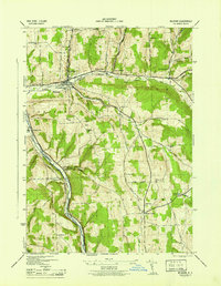
1944 Map of Mc Graw
USGS Topo · Published 1944About this map
McGraw serves as a primary hub of settlement in the mid-1940s, situated at the junction of several valley roads and the Delaware Lackawanna and Western railroad. The landscape is defined by the steep elevation changes between the Tioughnioga River valley and the surrounding uplands, such as Hicks Hill and Snyder Hill. This era shows a community still deeply connected to its rural infrastructure, evidenced by the high density of district schools including the White Schoolhouse, Old Stone Sch, and Shearer Sch scattered across the townships of Cortlandville and Solon. Significant local history is preserved in the numerous family and community burial grounds, such as Maplewood Cem and Mc Grawville Rural Cem. The map provides a clear record of the area's agricultural and transit-oriented development before modern interstate expansion altered the regional flow through Hoxie Gorge.
Find a feature on this map
45 named features on this map. Tap any name to fly to it.
Don’t see what you’re looking for? This feature index may not catch every label — zoom into the map to look around manually.
Map Details
Editions of this 1944 Mc Graw Map
This is the sole edition of this map. No revisions or reprints were ever made.
Other maps of this area

1903 · Cortland
USGS Topo · 1:62,500

1903 · Harford
USGS Topo · 1:62,500

1904 · Greene
USGS Topo · 1:62,500

1904 · Pitcher
USGS Topo · 1:62,500

1906 · Catatonk
USGS Topo · 1:125,000

1943 · Cincinnatus
USGS Topo · 1:24,000

1943 · Cuyler
USGS Topo · 1:24,000
1944 · Homer
USGS Topo · 1:31,680

1944 · Cortland
USGS Topo · 1:31,680
1944 · Cuyler
USGS Topo · 1:31,680