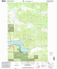
1997 Map of Mc Gregor Peak
USGS Topo · Published 2000About this map
Mc Gregor Lake dominates this Montana landscape, where the waters of the Pleasant Valley Fisher River and Bear Springs Creek traverse the high country of the Kootenai National Forest. Human presence is marked by recreation and utility, with Paradise Lodge and Boisvert Camp serving as focal points for those entering the forest from the lake's northern shore. The terrain is defined by the sharp rise of McGregor Peak and the open expanse of Lost Prairie.
Find a feature on this map
16 named features on this map. Tap any name to fly to it.
Don’t see what you’re looking for? This feature index may not catch every label — zoom into the map to look around manually.
Map Details
Editions of this 1997 Mc Gregor Peak Map
This is the sole edition of this map. No revisions or reprints were ever made.
Other maps of this area

1956 · Wallace
USGS Topo · 1:250,000

1957 · Kalispell
USGS Topo · 1:250,000

1960 · Kalispell
USGS Topo · 1:250,000

1960 · Wallace
USGS Topo · 1:250,000

1961 · Kalispell
USGS Topo · 1:250,000

1964 · Meadow Peak
USGS Topo · 1:24,000
1964 · Pleasant Valley Mountain
USGS Topo · 1:24,000

1964 · Hubbart Reservoir
USGS Topo · 1:24,000
1964 · Shroder Creek
USGS Topo · 1:24,000

1964 · Murr Peak
USGS Topo · 1:24,000