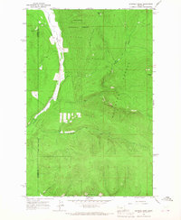
1964 Map of Shroder Creek
USGS Topo · Published 1967About this map
Kootenai National Forest and Lolo National Forest converge in this high-altitude landscape of northwest Montana, where the Sanders Co Flathead Co line bisects the territory. The Thompson River dominates the western corridor, its course winding through a narrow valley that separates the forest lands. This mid-1960s study captures the area's reliance on a network of high-country access routes, primarily the numerous Pack Trails that thread through the steep drainages of Shroder Creek and Murr Creek. Prominent summits like Bar Z Peak and North Peak serve as topographical anchors for this remote timberland. The map provides an essential record of the wilderness boundary and drainage systems before modern road development further altered the forest's primitive character.
Find a feature on this map
13 named features on this map. Tap any name to fly to it.
Don’t see what you’re looking for? This feature index may not catch every label — zoom into the map to look around manually.
Map Details
Editions of this 1964 Shroder Creek Map
This is the sole edition of this map. No revisions or reprints were ever made.
Other maps of this area

1920 · Jennings
USGS Topo · 1:125,000

1935 · Thompson Lakes
USGS Topo · 1:96,000

1937 · Thompson Falls
USGS Topo · 1:125,000

1942 · Thompson Lakes
USGS Topo · 1:125,000

1956 · Wallace
USGS Topo · 1:250,000

1957 · Kalispell
USGS Topo · 1:250,000

1960 · Kalispell
USGS Topo · 1:250,000

1960 · Wallace
USGS Topo · 1:250,000

1961 · Kalispell
USGS Topo · 1:250,000

1964 · Meadow Peak
USGS Topo · 1:24,000