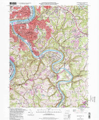
1993 Map of Mc Keesport
USGS Topo · Published 1998About this map
The confluence of the Monongahela River and Youghiogheny River anchors this study of Allegheny County’s industrial and residential heartland. This 1990s update reveals the intricate layout of Mc Keesport, Duquesne, and West Mifflin, reflecting a landscape heavily influenced by both steel heritage and suburban expansion. The density of religious and commemorative sites, from St Nicholas Cem to the Penn Lincoln Memorial Park Cem, provides a detailed record for genealogists tracing family histories in these river towns.
Find a feature on this map
87 named features on this map. Tap any name to fly to it.
Don’t see what you’re looking for? This feature index may not catch every label — zoom into the map to look around manually.
Map Details
Editions of this 1993 Mc Keesport Map
This is the sole edition of this map. No revisions or reprints were ever made.
Other maps of this area

1902 · Brownsville
USGS Topo · 1:62,500

1902 · Connellsville
USGS Topo · 1:62,500

1904 · Mc Keesport
USGS Topo · 1:62,500

1904 · Greensburg
USGS Topo · 1:62,500

1906 · Brownsville
USGS Topo · 1:62,500

1906 · Greensburg
USGS Topo · 1:62,500

1907 · Pittsburg
USGS Topo · 1:62,500

1931 · Brownsville
USGS Topo · 1:62,500

1931 · Connellsville
USGS Topo · 1:62,500

1933 · Brownsville
USGS Topo · 1:62,500