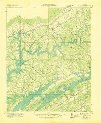
1936 Map of Mc Lean Rock
USGS Topo · Published 1936About this map
Norris Reservoir dominates this 1936 landscape, its jagged shoreline reaching deep into the valleys between Chestnut Ridge and Pine Ridge. The Tennessee Valley Authority's influence is clear, from the reservoir outline to the presence of CCC Camp TVA No 15 near the water's edge. To the north, Cumberland Mountain stands over established communities like Speedwell and Well Spring, where local life is anchored by the Speedwell Academy and various rural churches including Pleasant Hill Ch and New Salem Ch. This period represents a landscape in transition, where new federal projects border old industry such as the Lead Mine and family-named landmarks like Brady Grove Cem and Butcher Cem. Small hamlets such as Lickskillet and Pin Hook sit nestled in the ridges above the newly formed lake, while Maynardville serves as a hub to the south.
Find a feature on this map
63 named features on this map. Tap any name to fly to it.
Don’t see what you’re looking for? This feature index may not catch every label — zoom into the map to look around manually.
Map Details
Editions of this 1936 Mc Lean Rock Map
This is the sole edition of this map. No revisions or reprints were ever made.
Other maps of this area

1886 · Cumberland Gap
USGS Topo · 1:125,000

1888 · Cumberland Gap
USGS Topo · 1:125,000

1890 · Williamsburg
USGS Topo · 1:125,000

1891 · Cumberland Gap
USGS Topo · 1:125,000

1893 · Briceville
USGS Topo · 1:125,000

1894 · Williamsburg
USGS Topo · 1:125,000

1895 · Briceville
USGS Topo · 1:125,000

1896 · Briceville
USGS Topo · 1:125,000

1897 · Maynardville
USGS Topo · 1:125,000

1900 · Maynardville
USGS Topo · 1:125,000