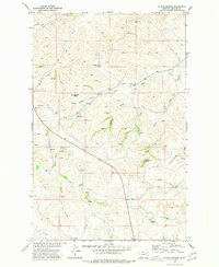
1973 Map of Mc Rae Springs
USGS Topo · Published 1977About this map
Hungry Creek Pass and Caprock Butte dominate this portion of the Missouri River Basin in McCone County, revealing a landscape defined by an intricate network of drainage coulees and seasonal water sources. The map highlights the critical importance of localized water for ranching and travel in this arid region, featuring numerous named water points like Mc Rae Springs, Alexander Springs, and Bielvins Spring. The land is carved by deep geographic features such as Scotsman Coulee, Beaver Coulee, and Costello Coulee, which channel runoff toward Bear Creek and Hungry Creek. This 1970s survey, developed by the U.S. Geological Survey, meticulously documents the complex topography of the high plains, where landmarks like Coal Hill and Bone Bluff provided essential orientation for those navigating the open range.
Find a feature on this map
29 named features on this map. Tap any name to fly to it.
Don’t see what you’re looking for? This feature index may not catch every label — zoom into the map to look around manually.
Map Details
Editions of this 1973 Mc Rae Springs Map
This is the sole edition of this map. No revisions or reprints were ever made.
Other maps of this area

1914 · Nashua
USGS Topo · 1:62,500

1915 · Frazer
USGS Topo · 1:62,500

1916 · Nashua
USGS Topo · 1:62,500

1954 · Jordan
USGS Topo · 1:250,000

1954 · Glasgow
USGS Topo · 1:250,000

1956 · Jordan
USGS Topo · 1:250,000

1957 · Glasgow
USGS Topo · 1:250,000

1958 · Glasgow
USGS Topo · 1:250,000

1958 · Jordan
USGS Topo · 1:250,000

1964 · Jordan
USGS Topo · 1:250,000