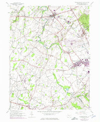
1944 Map of Mc Sherrystown
USGS Topo · Published 1975About this map
McSherrystown and New Oxford anchor this mid-century view of Adams County, where the agricultural landscape of Conewago and Oxford townships is defined by a dense network of country roads and one-room schools. The map preserves the locations of numerous local education sites, including Moritz Sch, Kohler Sch, and Felty Sch, alongside the prominent St Joseph Academy. The industrial and transit patterns of the era are visible in the junction at Berlin Jct and the rail line passing through Sells Sta.
Find a feature on this map
56 named features on this map. Tap any name to fly to it.
Don’t see what you’re looking for? This feature index may not catch every label — zoom into the map to look around manually.
Map Details
Editions of this 1944 Mc Sherrystown Map
4 editions found
Other maps of this area

1905 · Westminster
USGS Topo · 1:62,500

1908 · Gettysburg
USGS Topo · 1:62,500

1911 · Taneytown
USGS Topo · 1:62,500

1920 · Hanover
USGS Topo · 1:62,500

1922 · Hanover
USGS Topo · 1:62,500

1942 · Gettysburg
USGS Topo · 1:125,000

1944 · Manchester
USGS Topo · 1:31,680

1944 · Gettysburg
USGS Topo · 1:31,680

1944 · Mc Sherrystown
USGS Topo · 1:31,680

1944 · Littlestown
USGS Topo · 1:31,680